
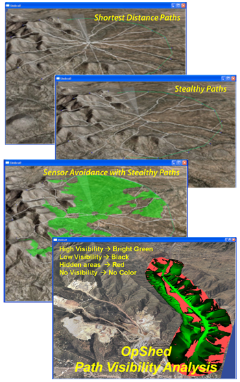
Interaction of physical structures, terrain, sensors, security forces, and adversaries in land-sea-air environments presents a complex situation for system analysis, design, and operation. OpShedTM enables quick study of sensor layouts to accelerate design and installation of security systems at secured facilities, perimeters, and borders.
If desired, OpShed can also shadow real-time operation as a tool to test sensors, evaluate performance, and consider forensic data in the field. Real-time activity in the region of study can be streamed into the tool to evaluate and compare simulated versus live sensor response. Because OpShed is built upon Umbra, simulated system behavior and simulated adversaries can be inserted to allow for a training system that matches the real equipment seen by the operators.
During design stages, security experts and decision makers can explore interaction of terrain, water, environmental conditions, buildings, technology, and security force operational procedures. Communication and cyber effects can be included. Simulated stimulus can be inserted, including wind driven objects, vehicles, animals, and a variety of human behaviors. Interaction between sensors and stimulus, given various environmental conditions, can be simulated with as much fidelity as required.
Existing sensor models in the tool include a variety of radars, wireless radios, imagers, cameras, and ground sensors. A high-fidelity terrain can be rapidly created and imported into the tool.
Validation of a site’s simulation or model can be simplified by streaming live field data into the tool. For instance, Radar sensor models can be validated at the site by recording real targets transmitting their GPS location as they travel through the terrain. Comparison is made between simulated sensor detection and real sensor detection so that sensor coefficients can be tuned for the specific site model. This validation may optionally be continued through operation for continuous monitoring of the system and simulation.
This tool has been used by facility analysts at multiple sites. It has been shown to significantly reduce the cost of designing and evaluating sensor performance. Analysts can now evaluate sensor performance within the tool with respect to the appropriate terrain to understand site regions that are well understood and to identify those regions that will benefit from real-time field testing. This tool was also used to specify sensor requirements of proposed new facilities before terrain modifications were performed at the site.